

An amber weather warning for heavy rain has come into force in parts of England, with the Met Office warning that affected areas could experience more than a month’s worth of rain falling on Monday.
Thunder, lightning and hail marked the official end to summer over the weekend, with the autumn equinox on Sunday afternoon signalling the start of the new season.
Rain warnings have been in place all weekend with a fresh yellow alert having come into effect at midnight to last all of Monday, covering parts of Wales, much of the south of England, the Midlands and into north-west England and Yorkshire.
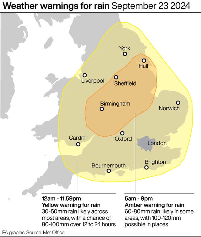
An amber warning came into force at 5am and will last until 9pm, sweeping over Worcester, Birmingham, Nottingham and Hull.
Some affected areas could see 100 to 120mm of rain on Monday and forecasters warned there may be more warnings in the week ahead.
Met Office meteorologist Jonathan Vautrey said: “First thing on Monday morning then we see an amber weather warning come into force.
“It stretches between Herefordshire, Gloucestershire and up towards the Wash and the Humber.
“This area in particular, during Monday, we could see over a month’s worth of rain falling, and with the rain we’ve already seen over the last couple of days this certainly has the potential to bring some disruption and flooding in locations and here it is very important we do take care over the course of the day.
“There is a broader yellow rain warning that encompasses much other areas of England and Wales as well.”

Even before the warnings came into effect, Bedfordshire Police said: “We are aware of the multiple issues the weather is causing across the county tonight. Please only call us if there is an immediate threat to life or crime in progress.
“All emergency services and council teams are working as quickly as possible to help those affected but our priority will be the vulnerable. Please stay clear of flooded roads and affected areas.”
As of 5am, 13 flood warnings – meaning flooding is expected – were issued for England by the Environment Agency.
Areas affected by the flood warnings include Atherstone in Warwickshire, Leighton Buzzard and Luton in Bedfordshire and parts of London including Wimbledon and South Ruislip.
Mr Vautrey also warned that temperatures are set to drop to below-average levels for the time of year across the country.
He said: “During the forthcoming week, though, we see northerly winds starting to push their way in, so the cooling trend is going to continue for all of us.
“Parts of Scotland will certainly see that by already Monday and into Tuesday, with temperatures slipping down into the low teens in places, but that cool and cold air will eventually reach many areas of the UK by the time we head throughout the rest of the week.
“So all of us will start to see temperatures dropping below average for the time of year as we head towards the end of the week.”


Comments: Our rules
We want our comments to be a lively and valuable part of our community - a place where readers can debate and engage with the most important local issues. The ability to comment on our stories is a privilege, not a right, however, and that privilege may be withdrawn if it is abused or misused.
Please report any comments that break our rules.
Read the rules here